Ramechhap District
About 63 results (0.61 seconds)
 DigiNepal Placesdiginpl.com › places › ramechhap district
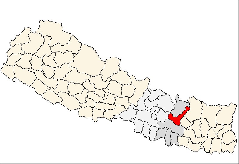
Ramechhap District
PlaceRamechhap District (Nepali: रामेछाप जिल्ला), a part of Bagmati Province, is one of the seventy-seven districts of Nepal. The district, also known as Wallo Kirat Ramechhap, has its district headquarters in Manthali and covers an area…
 DigiNepal Placesdiginpl.com › places › majuwa ramechhap
Majuwa, Ramechhap
PlaceMajuwa is a Village Development Committee in Ramechhap District in the Janakpur Zone of north-eastern Nepal. At the time of the 1991 Nepal census it had a population of 2,516 people residing in 423 individual households. मजुवा, रामेछाप…
DigiNepal Placesdiginpl.com › places › puranagauPuranagau
PlacePuranagau is a village development committee in Ramechhap District in the Janakpur Zone of north-eastern Nepal. At the time of the 1991 Nepal census it had a population of 2,866 people living in 242 individual households. पुरानागाउँ…
DigiNepal Placesdiginpl.com › places › kathjorKathjor
PlaceKathajor is a village development committee in Ramechhap District in the Janakpur Zone of north-eastern Nepal. At the time of the 1991 Nepal census it had a population of 4,421 people living in 786 individual households. कठजोर नेपालको…
DigiNepal Placesdiginpl.com › places › ramechhap ramechhapRamechhap, Ramechhap
PlaceRamechhap Municipality is a municipality in Ramechhap District in Bagmati Province of Nepal. It was established on 2 December 2014 by merging the former village development committees Old-Ramechhap, Okhreni and Sukajor. At the time…
 DigiNepal Placesdiginpl.com › places › lakhanpur ramechhap
Lakhanpur, Ramechhap
PlaceLakhanpur is a Village Development Committee in Ramechhap District in the Janakpur Zone of north-eastern Nepal. At the time of the 1991 Nepal census it had a population of 6,058 people residing in 1,100 individual households. लखनपुर,…
 DigiNepal Placesdiginpl.com › places › gupteshwar ramechhap
Gupteshwar, Ramechhap
PlaceGupteshwar is a village development committee in Ramechhap District in the Janakpur Zone of north-eastern Nepal. At the time of the 1991 Nepal census it had a population of 1,708 people living in 310 individual households. गुप्तेश्वर,…
DigiNepal Placesdiginpl.com › places › ramechhap airportRamechhap Airport
PlaceRamechhap Airport is a domestic airport serving the municipality of Manthali, the district headquarters of Ramechhap District located in the Tamakoshi River valley in Bagmati Province in Nepal. As of October 2022, most flights to Lukla…
 DigiNepal Placesdiginpl.com › kb › axz › places
Likhu Chuli: mountain in Nepal
Place…Pig Pherago Shar, is a mountain in Nepal. Type: mountain. Located in: Ramechhap District, Solukhumbu District. Elevation: 6,719 m. Coordinates: 27.8088 N, 86.5409 E. Sources: Wikipedia and Wikidata (Q20757627). License: CC BY-SA 4.0…
DigiNepal Placesdiginpl.com › places › deurali ramechhapDeurali, Ramechhap
PlaceDeurali, Ramechhap is a village development committee in Ramechhap District in the Janakpur Zone of north-eastern Nepal. At the time of the 1991 Nepal census it had a population of 3,459. देउराली, रामेछाप नेपालको पूर्व प्रशासनिक विभाजन…
Related searches
Privacy: we keep only the text of searches, counted in aggregate, to improve results. No IP address, account or device is stored with it, and searches with personal details are not kept. Web results are fetched by our server, so providers never see who you are.