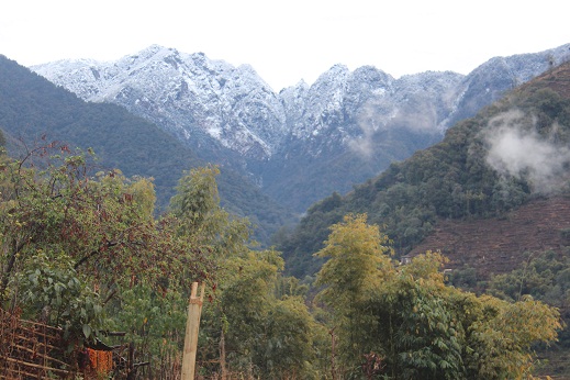
Sungdel
सुङदेल
Village development committee in Sagarmatha Zone, Nepal
नेपालीमा पढ्नुहोस् · हिंदी में पढ़ें
- नेपाली · English · हिंदीRead in your language
- CitedEvery fact sourced
- Ad-freeNo ads, no tracking
Sungdel is a village and Village Development Committee in the Khotang District in the Sagarmatha Zone of eastern Nepal. At the time of the 1991 Nepal census it had a population of 2,846 persons living in 585 individual households. It is at the northeast belt of the Khotang district. Currently, there is a high school, Shree surya Ma. Vi, and four primary schools. People run their own hydropower. The majority of people are Koyee Rai. It is the only place where Koyee people speak their mother language, Koyee. This language is also known as Sungdele Bhasa. Most people depend on farming. The highest hill in Khotang district, Loure, is situated in Sungdel.
Quick facts
- Type
- ward of Nepal wd
- Located in
- Khotang District (district of Nepal) › Koshi Province (province of Nepal) wd
- Coordinates
- 27.3800° N, 86.8900° E wd
Nearby places
- Rakha Dipsung — 3 km
- Sitalpati, Sindhuli — 5 km
- Rakha Bangdel — 7 km
- Khartamchha — 7 km
- Baksila — 8 km
- Baspani, Khotang District — 9 km
Related
 Mount EverestEarth's highest mountain
 HimalayasMountain range in Asia
 KathmanduCapital and largest city in Nepal
 Kangchenjunga3rd-highest mountain on Earth
 Annapurna (mountain range)Mountain range in the Himalayas
 Dhaulagiri7th-highest mountain on Earth
 Makalu5th-highest mountain on Earth
 Lhotse4th-highest mountain on Earth
 Cho Oyu6th-highest mountain on Earth
 Manaslu8th-highest mountain on Earth
 PokharaMetropolitan city in Gandaki Province, Nepal
 LumbiniHistorical city in Lumbini Province, Nepal
Questions
- Where is Sungdel located?
- Sungdel is located in Khotang District, Koshi Province, Nepal.
Sources
- Wikipedia (English): Sungdel · CC BY-SA 4.0
- Wikipedia (Nepali): सुङदेल · CC BY-SA 4.0
- Wikidata item Q3414526 · CC0 1.0
- Image: Sungdel.JPG by Sumankoyee (CC BY-SA 4.0)

Last updated · facts checked 3 November 2026
Cite this page
"Sungdel". DigiNepal. Last updated 31 October 2026. https://diginpl.com/places/sungdel. Retrieved 3 November 2026.